Pages

Saturday, November 30, 2013

Travel Guides for Dong Nai Province

Dong Nai Province, Vietnam travel guides
Capital: Bien Hoa City
Ethnic groups: Viet (Kinh), Hoa, Xtieng, Cho Ro, Cham Highlights: Cat Tien National Park, Tri An Waterfall, Hang Gon Tomb, Tan Trieu Pomelo Village

Where to travel around:

Tran Bien Temple of Literature
The temple of literature was built in the late 17th century in Buu Long Ward, Bien Hoa City. Like the Temple of Literature in Ha Noi, Tran Bien was a university for students in the South. This structure showed the tradition of encouraging and enjoying study of southerners. In December 1861 when French troops occupied Bien Hoa, this temple was destroyed. It was rebuilt in the late 20th century so that the generations of today understand the history of Vietnamese education. The new Tran Bien Temple of Literature has architectural style of the Temple of Literature in Ha Noi.
Annually, there takes place two major events in the temple. They are Xuan Vinh in the 2nd lunar month and Thu Vinh in the 8th lunar month.

Tan Trieu Pomelo Ecological VillageTan Trieu Pomelo Ecological Village belongs to Tan Binh Commune, Vinh Cuu District, 25km from Bien Hoa City, is well known for its many pomelo orchards. Visitors are likely to be offered fruit samples to taste the variety of pomelos available at Tan Trieu.
The thanh tra pomelo is easily recognizable for its mild sweetness and sour taste. Residents of Ho Chi Minh City often go on picnics to Tan Trieu Pomelo Village.

Buu Long Tourist Park
Buu Long Tourist Park covers some 84 ha on the outskirts of Bien Hoa City, 6km from city centre, 30km from Ho Chi Minh City. It is a landscape with mountains, pagodas and a large lake, some people excessively call Ha Long Bay in miniature".
The Tourist Park embraces Long An Lake, an artificial reservoir covering an area of more than 10 ha. The crystal clear lake has plenty of large rocks that have the look of small islets.
 Boats will carry visitors around the lake, and to an islet in the middle of the lake. Climbing 35m to the top of the islet, you will watch scenery of zocks and trees make the surroundings cool and pleasant, and help visitors take a comfortable rest after climbing nearly 100 steps.
Close to the lake is Buu Long mount, which reflects itself on the lake, creating beautiful scenery. Buu Phong Pagoda was built in the 17th century on the mountain. Nearly 100 steps must be climbed to reach the pagoda. The pagoda was only a thatch roofed hut at first, and was renovated and enlarged in 1829. More renovations have been made recently.
Many ancient artifacts are left at the pagoda, including clothes dating back to the Nguyen Dynasty, and lying Buddha statues. Around the pagoda are several towers, large rocks of strange shapes and very big Bodhi trees. The rocks and trees make the surroundings cool and pleasant, and help visitors take a comfortable rest after climbing nearly 100 steps.
Nearby the pagoda is Long Son Thach Grotto, meaning "the Grotto of the Dragon Mount", which contains many stalactites of different shapes, sizes and colours. The entire grotto looks like a frog's jaw.
The top of Mount Buu Long provides you with a panorama of Bien Hoa City, which houses many factories of Vietnamese and foreign companies. Also from the top, visitors can see a green stretch of fields interwoven with branches of the Dong Nai River, all creating a mountain-river-country picture.

Tri An Lake
Tri An Lake is located in Vinh An Town, Vinh Cuu District, 65km from Ho Chi Minh City and 30km from Bien Hoa City. This is a 32,000-ha lake with fresh water and 36 islands. Above of the other islands, there are two adjacent attractive ones: Falcon Island and Dong Truong Island. These two islands have beautiful, poetic and charming sights with fresh air. Tri An lake is a wonderful place to natural lovers.

Cat Tien National Park - the most interested site for those travel to Dong Nai
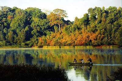
Cat Tien Forest Vietnam National Park
Cat Tien Forest - A Vietnam National Park
The Cat Tien National Park, known for long time as the land of crocodiles, and is globally considered the 411th biosphere reserve. The Park's area covers apart of three provinces of Dong Nai, Binh Phuoc and Lam Dong. This Park with an area of 70,548 ha consists of the Nam Cat Tien Protected Forest (39,108ha) in Dong Nai Province, extended part (26,970ha) of Lam Dong Province, and Binh Phuoc Province (4,470ha).
This natural habitat has a diverse and rich ecosystem. The Park treasures 1,362 plant species (440 timber species, 310 medicinal plants, 220 ornamental plant species, 133 orchid species). The fauna includes 62 animal species, 25 of which are listed in Viet Nam's Red Book; and 121 bird species, few of which are classified as rare species such as the white-necked cranes, Indian storks, pheasants (ga loi hong tia), ibis (co quam xanh), one-horned rhinoceros (te giac mot sung), elephants, etc.
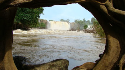
The Park also has diversified landscapes: hills, alluvial grounds, flat large grounds, strong water currents. In the rainy season, mild springs turn out fierce ones with tremendous water flows on large stones. However, meandering waterfalls create lovely yellow sandy beaches like natural beaches. Legend has it that fairies frequented this place to enjoy the cool and clean water, so it is named Nam Cat Tien (Fairy Sand). In the middle of the large river stand several islands. On the islands are old trees alternating with large grass grounds, which are the ideal place for overnight camping. Cat Tien has preserved from the past historical and cultural sites. In the past war, this place was a revolutionary base. Archaeologists have discovered remains of the Oc-Eo culture dating from the 2nd to 7th centuries AD Built at the peak of a hill near the Dong Nai River in Quang Ngai Commune, Cat Tien District, Lam Dong Province, the temple dedicated to deities belongs to the culture of Funan, a kingdom that was left unnoticed for over 1,300 years. Even now people still talk about the myths and legends associated with the construction of the temple. The Cat Tien National Park is one of the most attractive cultural and eco-tourism destinations in the Southeast Region. Tourists can experience all kinds of tours including trekking, camping, observation of animals at night to learn the life of the wild, visits to ethnic villages, boating on the Dong Nai River or Bau Sau Lake, and other adventurous tours. To reach Cat Tien National Park, from Ho Chi Minh City take National Highway 20 or go the same road to Da Lat.
Hang Gon Ancient Tomb
Hang Gon Ancient Tomb, built more than 2,500 years ago, was listed as a Historic Site by the State. The peculiar trait of the tomb is that it has been built with large flat stones. It is regarded as a type of South East Asian dolmen or megalithic construction. The ancient tomb is located in Xuan Tan Commune, Long Khanh Town, approximately 80km from Bien Hoa City.

Travel Guides for Dong Nai Province

Sunday, November 24, 2013

Biking tour along Central Region of Vietnam

Biking tour along Central Region of Vietnam for both amateurs and professional bikers - Heading off the beaten track to explore rural life and take in the beautiful scenery of central Vietnam.

The Central Region untouched by modern life is extremely attractive to tourist, partly for its immense blue sea, the idyllic villages and fields that run along both sides of the main trunk highway. How exciting to leave the national highway and bike head off to explore the un-spoilt inland provinces. To explore the local communes, towns and villages. It’s unsure when this craze first started, but cycling heading off into the central regions of Vietnam has become very popular. This is especially so for European tourists, even despite the scorching heat and dry winds, they still flock to this region.


Professional bike tour organizer of Vietnam, Hung, or “Joe” to his foreign friends, has dark tanned skin. He is an expert on the biking routes on both sides of the North-South main trunk road. To be able to setup an attractive journey for adventurous tourists the tour organizer must find out the most interesting routes, both adventurous and safe. Many of tourists have already cycled under the blazing sun of the Sahara or in the snowy Swiss Alps. Mr Joe avoids state highway no.1, because of the cars, big trucks and countless buses. He instead takes bikers through the villages and towns. Crossing fields and coastal roads are his favorite places as the tourists can enjoy the full feeling of rural life. He knows where the bikers should stop to shoot pictures. Similarly to sport biking, the bikers should stop every 10 to 15 km to rest and take in some food and water for the next cycling miles.

In Vietnam, GPS is not necessarily as it is not as dangerous as getting lost in Sahara. But some tourists still have to hire o local to guide them back to the main road after getting lost in the network of village paths. Biking routs from Hue to Hoi An, From Tam Ky to Quy Nhon, along the coastal road to Nha Trang then to Da Lat or biking through Phan Thiet to Ho Chi Minh City, the commune roads don’t have many sign posts, however, guest can see real local life, meet and talk with the local people. It is fantastic to bike through and around crowds of students bicycling home in their white Ao Dai’s and conical hat, like a swarm of butterflies. In Binh Dinh countryside, on the coastal roads, the tourists find many interesting thing to see. They can breathe the fresh sea breeze and watch the fishing boats bring their daily catches into the local markets. Also on these small roads, the bikers can enjoy mouth-wetting, cheap seafood, very different from eating in air-conditioned, expensive restaurants in the cities.

The most difficult route among Central Vietnam biking routs is along the tarmac roads through the hot sand dunes in Quang Ngai, there are no trees for ten kilometers. The most idyllic moments are biking in the yellow sunset along Thu Bon river, with its lush gardens and paddy fields on its bank. The Central Region’s landscape changes a lot in each area, some area very verdure alluvial plains, some are dry and hot. The society’s development is changing quickly, but luckily it is still retains much of its countryside beauty and untouched landscapes. This makes biking in the Central Region of Vietnam very attractive for visitors. Not only professional bikers who have biked in many countries around the world are fond of these tours, there is an increasing number of amateur bikers who want adventure and to explore the countryside of Vietnam, under the guidance and watchful eye of tour organizer.

www.vietnamtravelguidelines.com - Biking tour along Central Region of Vietnam.

Saturday, November 23, 2013

Destinations for Tourist around Dak Nong

Where to go around Dak Nong for Tourist

Capital: Gia Nghia Town
Ethnic groups: Viet (Kinh), E De, Nung, M'Nong, Tay
Highlights: Dray Sap waterfall, Dieu Thanh water fall, Ba Tang waterfall

Tourist Destinations of Dak Nong

Dray Sap Waterfall
Some 30 kilometers from Buon Ma Thuot City lies Dray Sap Waterfall, which means "the Misty Waterfall". This name is derived from a legend of love story between a boy and a girl who lived in this area. Everyday, H'Mi - name of the girl used to go to the milpa with her lover. One day, while resting on a flat stone, they saw a monster, whose head was as big as a mountain, eyes like bronze urns. Its body was glittery with silvery scales. Suddenly, the monster dived down from the sky and his trunk plunged into the ground, stirring up a colossal column of water. The monster spread out its large wings, flew around several times, making a fierce rain then flied away. In terrible shock, the girl disappeared into the mist. The boy was transformed into a big stump, whose roots stuck into the rock. This place was then called the Dray Sap, or Misty Waterfall.
The rains impetuously rumble down and all of a sudden stop. The sunshine filtered through foliages, making the waterfall look more miraculous. This stream looks like a mixture of water and clouds. Tourists will feel at ease here.
Nature has endowed Dray Sap Waterfall the rugged beauty of mountain and forest. The legend of the love story adds more colours to this waterfall. Save your time to visit Dray Sap Waterfall, to enjoy the pure air at night, to welcome the dawn, to hear the chirping of birds, and to have a sense of how beautiful life is!

Dray Sap Waterfall tourist Dak Nong Vietnam
Dray Sap Waterfall

Trinh Nu Waterfall - waterfall for tourist around Dak NongBefore discharging into the Serepok River, the Krong No stream snakes its way through rocky stones of many shapes and sizes, creating a magnificent natural landscape called Trinh Nu (Virgin) Waterfall. Legend has it that the name of the waterfall stemmed from a moving love story. A girl at the age of puberty had to commit suicide in the waterfall to ease her heart-rending love story, hence the name Trinh Nu Waterfall, one of the most famous tourist attractions in the Central Highlands.
Trinh Nu Waterfall is situated 1km from the town center of Cu Jut District. On the way to the waterfall, one seems to blend with nature. From a distance, the sound of the waterfall can be heard. Amidst the imposing natural landscape, tourists feel free from all the trouble of life.
Coming here, tourists have a chance to enjoy the natural beauties as well as the excellent services.

Dieu Thanh Waterfall
For a long time, Dieu Thanh Waterfall has won kudos for its pristine and poetic beauty. Dieu Thanh Waterfall is located on Dak Tit Stream, the natural border between Nhan Co Commune (Dak R'Lap District) and Quang Tan Commune (Tuy Due District). This waterfall has been stood in the middle of mountain and forest since time immemorial, despite various changes of the surrounding scene and natural environment.
Besides the biggest water column, which comes down from the height of 30m, Dieu Thanh Waterfall also comprises of some small other water columns, creating a thin mist that cools down the temperature at the foot of the rocky mountain. Under the waterfall, there are several deep grottoes and inside them there have many large and smooth rocks for tourists to take a short rest. The temperature here is always cool. When standing on the summit of the waterfall, you can admire a part of the magnificent mountain and forest of the Central Highlands.
Though Dieu Thanh is located in a calm place of jungle but it is still one of the interesting beautiful spots which not only attracts visitors in Dak Nong Province but also in other provinces such as: Dak Lak, Binh Duong, Binh Phuoc, Ho Chi Minh City and so on. Especially on festivals or Tet holidays, a lot of people flock to this place.
 
Ba Tang Waterfall - As a tourist destination of Dak Nong
It is a beautiful spot, 8km from Gia Nghia Town. To reach this waterfall, go along National Highway No14 in the contrary direction to Buon Ma Thuot. The waterfall cascades down over three levels before reaching the stream below, hence its name Ba Tang (three-storey cascade). The waterfall is about 40 m high. The first layer is not too high, water falls down from the height of 1.5m to the bottom. The second one is about 20m from the first one. In this layer, the clear blue stream flows through rocks and from a height of 2m, the water overflows downward, creating white spume. The third layer, about 20m from the second, the biggest and the main one of this waterfall, is 20m high, overflowing in two sides of the stream.
The spring is quite wide; its two banks are covered by shady trees where tourists may take a rest and enjoy the natural beauty. Looking upward, it seems to us that there is a misty veil created by the powerful flow of the falling water in an ever roaring sound.
The waterfall is surrounded by old trees. There is a large, flat ground for visitors camping, and relaxing. Together with Dieu Thanh Waterfall, Ba Tang Waterfall creates a place "S for interesting trekking tours in Dak Nong Province

Gia Long Waterfall
Gia Long Waterfall is located in Dak Sor Commune, Krong No District. Gia Long is the upper waterfall in the system of Gia Long, Dray Nur and Dray Sap waterfalls of Serepok River.
Formerly, Emperor Gia Long had a nice road built to reach this waterfall. He also intended to build a suspension bridge across the waterfall. However, the bridge was never completed and no one knows why only two bridge's piers were dug, which still remain now.
The beautiful landscape of waterfall and clear and pure lake makes the site attractive to natural lovers. 

Gia Long Waterfall tourist Dak Nong
Some Tourist on Gia Long Waterfall

Pu Prang M'Nong Village tourist destination of Dak Nong
From Gia Nghia Town, following Highway 14 towards Buon Ma Thuot City for about 28km then turn left for 2.5 km, tourists will arrive at the Pu Prang Village (Dak Rung Commune, Dak'Song District) where still preserves many unique M'Nong cultural features, works of folk literature such as: the anthem, the epic...
Pu Prang Village preserves more than 200 epics of M'Nong ethnic group (also called Ot-Nrong). The epic collection has great human values (genealogy epic set). In the village, family of Dieu Kau artist has been studying, collecting, compiling and storing hundreds of Ot-Nrong of this region. The way to show the Ot-Nrong songs is to sing (sing at mountain field, nearby the cooking fire, in the festivals...). Ot-Nrong singing expresses high solidarity in family and community, associates with the education of community tradition and is indispensable to M'Nong people after hard working days.
Coming to Pu Prang Village, visitors will have opportunity to visit the graves of M'Nong peo-pie. These are traditional relics showing decorative art; symbols and patterns elaborately carved on wood reflect the beliefs of M'Nong ethnic group. Visitors will be able to join many festivals of the ethnic minorities here if visiting the village in March.

Destinations for Tourist around Dak Nong

Saturday, November 16, 2013

Where to go around Quang Tri Province

Quang Tri, Vietnam Where to go around

Capital: Dong Ha City
Ethnic groups: Viet (Kinh), Bru -Van Kieu, Ta Oi, Hoa
Highlights: Khe Sanh Combat Base, Vinh Moc Tunnels, Truong Son National Cemetery, Quang Tri Citadel

Tourist Attractions of Quang Tri, Vietnam
 
Khe Sanh Combat Base
Khe Sanh is a valley surrounded entirely by rolling mountains and forest. Geographically, it is very similar to Dien Bien Phu. It used to be an American defence station that was believed to be unassailable.
More than 10,000 army men, not to mention many other troops ready to intervene, were stationed there.However, after 5 months of intensive battles, the Vietnamese Liberation Army succeeded in taking over Khe Sanh.

Vinh Moc TunnelsVinh Moc Tunnels 
The Vinh Moc Tunnels are a unique infrastructure of tens of underground passages in the village of Vinh Linh District. The tunnels were dug while the country was at the anti-American war, between 1965 and 1966.
The tunnels used to be thousands of meters long. But now there remain only 1,700m. This underground network is linked with 13 doors (seven opening to the sea and six to the hills). The structure is divided into three layers, the deepest being 23m underground. They are connected by a 768m main axis that is 1.6 to 1.8m high and 1.2 to 1.5m wide.
Along the two sides of the main axis are housing chambers. There is also a large 3 meeting hall with a seating capacity of 50 to 80 people, which was used for meetings, movies, art performances, surgeries, and even the delivery of babies (17 were born here). There are also four air wells, two watch stations and three water wells.
Visiting the tunnels, tourists seem to be living in the wartime, and they can meet with friendly locals who recorded numerous wonderful victories.


Truong Son National Cemetery - Quang Tri where to go around
The cemetery is located on a hill surrounded by eight hills like an eight-petal flower in Vinh Truong Commune, Gio Linh District, Quang Tri Province, close to Road No15, 25km north-west of Dong Ha City. It is 106 ha in area. The main part, 40 ha, houses 10,263 tombs of fallen soldiers and is divided into 24 smaller sections which are categorized according to localities. This part is located in 6 hills, and the memorial monument is situated on the highest hill. The Memorial of the Nation to Soldiers' Sacrifices has three sides representing the three Indochinese countries leaning on each other to fight the enemy. Between sections 4 and 5 is a group of monuments in memory of the heroism of Battalion 559 and Vietnam-Laos solidarity.
The cemetery is the resting-place of soldiers who fell on the Ho Chi Minh Trail, which has become part of the history of anti-American war, and in battlefields in the Central part of the country. This is the biggest, highly artistic memorial site showing the people's deep sorrow, gratitude and respect for those who have sacrificed their lives for the liberation of the nation. Every year, it welcomes thousands of visitors from around the country. Many foreigners have crossed thousands of miles to visit it. Truong Son National Cemetery is 9km south of the Ben Hai River.

Quang Tri Citadel
The citadel was built in 1824, the fourth year of the Minh Mang's reign, in Thach Han Commune, Trieu Hai District.
It is nearly 3km in perimeter and 4m in height. It has four doors looking to the main four directions: east, west, south, and north. Outside its walls is a trench 18m wide.
In 1972, during the anti-American resistance war for national salvation, Vietnamese liberation soldiers stationed at the citadel had to cope with American and South Vietnamese armies' huge bombings as eight times destructive as the nuclear bomb the US dropped onto Hirosima of Japan in 1945. The soldiers, however, were determined to protect the citadel for 81 consecutive days and nights, from 28 June to 16 September 1972, despite the extremely grave situation. The citadel has gone down in history as a glorious symbol of the nation's war against foreign invasion. The Vietnamese people are proud of it, and foreigners admire it.
Looking at its walls riddled with bullet holes, visitors will feel how devastating the war was. In order to commemorate the soldiers' meritorious service, a monument was set up in the centre of the citadel as a symbol of the indomitable spirit of the Quang Tri people and O army and as a token of gratitude to the sacrifices of the fallen soldiers for the independence and freedom of the nation.

where to go for tourist around Quang Tri
A gate of Quang Tri Citadel

Dakrong Beauty Spot
Dakrong beauty spot is the general name of an area graced with the romantic and majestic natural scenery of the mountains west of Quang Tri. The Dakrong River, that inspired many epic and cultural legends, runs through the area.
Over the river shrouded in mist, stands the charming Dakrong Bridge. Waterways, mountains and forest stretch as far as your eye can see. Nearby, there is a precious natural mineral water source.
Dakrong was an important site on the Ho Chi Minh Trail. Now highway 9, the Trans-Asia Highway, passed through this site en route to the international border gate in Lao Bao - Den Sa Van.

Ben Hai River and Hien Luong Bridge - A Tourist Attractions of Quang Tri, Vietnam
Ben Hai River, also known as Rao Thanh River, starts from Truong Son Mountains and runs 100km through it to meet the sea at Cua Tung (Tung River Mouth). The widest part of the river is about 200m. The portion covered by Hien Luong Bridge is approximately 170m wide.
Prior to the construction of the steel bridge, supervised by a French army engineer in 1950, the only way to cross the river was by boat. The bridge is 178m long and has seven girders. Its surface was made of wooden planks.
Under the Geneva Accord on Vietnam signed in 1954, the Ben Hai River was selected as a temporary demarcation line separating the country into two parts for military regrouping purposes. Hien Luong Bridge was then divided into two parts, each part serving as a border gate.
Today, Hien Luong Bridge has become a historic landmark and a great tourist attraction.

Cua Tung Beach
Although Cua Tung Beach is not very wide or long, it has its own beauty. The beach has sparkling blue water, silky sand, and it is touched by soft breezes throughout the year.
It is very pleasant to go on a boat down stream on the Ben Hai River and view the beautiful landscape. From Hien Luong Bridge, the tour boat will bring visitors along the river where rice and maize fields, green bamboo belts, rows of Casuarinas trees, and villages are visible far off into the distance.
In the evening, there are many albatross flying across the sky and diving down into the blue water. As night falls, it is time for wind and sea music, the sound of the waves and the whisper made by the rows of casuarinas trees.
Cua Tung is no doubt a great place for both a holiday and a rest.

Truong Son Trail - where to go around for tourist to Quang Tri
In late 1950s and early 1960s, the goods and ammunition were transported by human physical strength from the North to the South of Vietnam in service of the resistance against the US aggressors. It took six months to a year for each batch of goods to reach the south. The requirements from the battlefields posed an urgent need of mechanized means of transport. In May 1959, the Truong Son Trail was officially put into use. Later, it developed a network of crisscrossed roads, winding alongside with the Truong Son mountain range. The section in Quang Tri was considered the most pivotal point.
During the resistance, Truong Son Trail was subjected to the US fierce bombings. As the US and its lackeys failed to cut off the flow of goods from the north to the south, they launched many operations and used paratroops in the hope of destroying this supply source. Moreover, they also utilized modern electronic means to detect the targets such as electronic fences, recorders. However, the Truong Son Trail was not only protected, but also expanding on a par with the requirement from various battlefields. It spanned over 20,000km, including five main arteries, 13 crossroads, and four parallel axes. Despite numerous difficulties, the Vietnamese soldiers still ensured the smooth transportation in this trail.
Statistical data show that during the 5920 days the Truong Son Trail was put into operation, the enemy launched 800,000 sorties, of which 30,000 sorties of B-52, throwing 2.5 million tons of bombs. They launched all together 1,300 operations. The Vietnamese soldiers downed 2,455 aircrafts, putting out of action 18,470 enemy soldiers.
The Truong Son Trail, now the Ho Chi Minh Road, has gone into history as a historical evidence of the strength of our all-people war, the staunchness and bravery of the Vietnamese people.

Where to go around for tourist to Quang Tri

Friday, November 8, 2013

Tourist Guides for Bac Ninh Province Vietnam


Bac Ninh Province Tourist Guides
Capital: Bac Ninh City
Ethnic groups: Viet (Kinh), Tay, Nung, Muong
Highlights: But Thap Pagoda, Dinh Bang Communal House, Do Temple, Phat Tich Pagoda

Tourist Destinations of Bac Ninh

Complex of Ly Dynasty relics
Located in Dinh Bang Ward, Tu Son Town, the complex of Ly Dynasty relics includes Do Temple, Rong (Dragon) Temple, Thien Duc royal tomb, Co Phap Pagoda and Kim Dai Pagoda. From Ha Noi, visitors travel on highway 1A northeast for 15km to arrive in Tu Son Town, and then reach the complex of relics shortly.

Do Temple also called Co Phap or Ly Bat De (Eight Kings Ly) honours the eight Kings of Ly Dynasty. Regarded as a kingdom (Do) of the deceased kings Ly, the temple has long been called as Do Temple.

Do Temple Tourist destinations of Vietnam
Do Temple

Do Temple was built by King Ly Thai To (Ly Cong Uan) in 1019 and was enlarged by his son Ly Thai Tong in 1030. Since then the temple has been altered several times. The major reconstruction took place in 1602 during the reign of King Le Kinh Tong. In 1952, the temple was destroyed by the war and was restored in 1989 as original temple based on old documents.
Do Temple covers a total land area of 31,250m2 and it is divided into two parts: inner rampart and outer rampart. The inner rampart expands over 4,320m2, surrounded by 3m-high and 1m-wide brick walls. In the heart of the inner rampart is the main hall, which is comprised of 70m2 Phuong Dinh House, and 220m2 Tien Te House having the altar dedicated to King Ly Thai To. Next is the 180m2 Co Phap Shrine that houses ancestral tablets, sacred thrones and statues of the eight kings. The inner rampart also reserves a place for keeping palanquin and horses...
The outer rampart consists of a half - moon shaped lake with a floating pavilion and houses of Van Chi built in 2002 and Vo Chi built in 2005. Both houses share similarities in architectural layouts - Tien Duong (front) and Hau Cung (back) houses, ceremonial house, storehouse and guesthouse. The lake and floating pavilion is used to serve as a place for the former mandarins to watch water puppet show. Queen Temple (Den Vua Ba) which is dedicated to mothers-queen lies in the outer. Many valuable ancient objects and important historical documents are preserved in Do Temple. In particular, there is an old stele with the writing of Phung Khac Khoan, the winner of a feudal literature contest in 1602.
Do Temple contains Chieu Doi Do (the royal proclamation to change the capital city) with height of 4.5m and length of 10m. It consists of 214 Chinese characters made from pottery and adapted from Chieu Doi Do of King Ly Thai To. This work is to celebrate the 1000th birthday of Thang Long - Ha Noi. Besides, Dinh Bang Ward has some other relics such as Rong (dragon) Temple in Long Vi Hamlet, dedicated to Ly Chieu Hoang, the last king of the Ly Dynasty; Tho Lang Thien Duc (Thien Duc royal tombs) in Cao Lam Hamlet where Ly Kings' tombs are placed; Co Phap Pagoda, also called Dan Pagoda, nestling amidst Chua Dan Street and relating the legend said that Queen Mother Pham Thi gave birth to Ly Cong Uan in this pagoda on March 8, 974; and Kim Dai Pagoda, also called Luc To Pagoda in Xuan Dai Hamlet, where Ly Cong Uan used to stay to serve as a Buddhist novice.
 
Dong Ho Painting Village - Bac Ninh Province Tourist Guides
Located by the Duong River (Thuan Thanh District), Dong Ho is a nice village that specializes in making folk paintings.
Dong Ho's craft of making folk paintings has long come into existence. In the past, the villagers just made paintings before Tet Holiday (Lunar New Year's Day). Nowadays, tourists can buy paintings at any time in the year. Dong Ho villagers do not draw but use wood engravings to print paintings. A fine engraving requires dexterity of the pattern drawer. The painting must be printed on fine do papers. Colors for painting are obtained from such natural materials as half-baked bricks and ashes of some kinds of leaves and roots. In order to make the glittering background for do papers, the artisan burns scallop shells to a kind of powder which is refined and mixed with resin; and then the mixture is pasted on the paper sheet which will be used for painting.
Dong Ho's paintings have conventional layouts, contents, and colors. For a large part, the paintings reflex wishes for peace, happiness, and prosperity. Some paintings focus on animals such as cows, pigs, dogs, and cats, which are familiar with farming life. Particularly, such topics as "catching coconuts", "mice's wedding", and "jealousy" always attract tourists at home and abroad. Nowadays, Dong Ho villagers also make votive objects for traditional rituals.
Every Tet Festival, a paintings market is held at the Dong Ho Communal House, drawing visitors in quantity. Also at the communal house, a contest of votive objects is held from late 14th to 18th day of the third lunar month. These are two unique cultural events of Dong Ho Village.
 

Dinh Bang Communal House
Dinh Bang Communal House, located in Dinh Bang Village, Tu Son Town, 20km from Ha Noi, is very famous in the North of the country. Its construction started in 1700 and ended in 1736. The house is a place of worship for three tutelary spirits: Cao Son Dai Vuong, God of land, Thuy Ba Dai Vuong, God of water, and Bach Le Dai Vuong, God of harvest. The main part of the communal house is rectangular, 20m long and 14m wide, and it is divided into seven rooms. It is very imposing Duc to its large roof and its 60 or so ironwood pillars, which range in diameter from 55 to 65cm. The design of the components is very complex and the structure is very sturdy. There is a panel inscribed with Chinese characters that is read in Vietnamese as Bat Ma Quan Phi, which means Eight Running Horses.
To get to Dinh Bang Village from Ha Noi, cross the Red River on the Chuong Duong Bridge and then take National Highway 1Afor nearly 20km. Dinh Bang, which is rich in sites of historical interest, is one of the 20 traditional handicraft villages of Bac Ninh. In Dinh Bang, people are experts in lacquer-ware. Moreover, almost everyone in the village sings quan ho. People of all ages and of both genders express their feelings through lyrics that bear a deep national character.

Pagodas as Tourist Destinations in Bac Ninh Province

1/ Dau Pagoda - Bac Ninh Province Tourist Guides
Dau Pagoda is located in Thanh Khuong Commune, Thuan Thanh District, 30km from Ha Noi. It was built at the beginning of the 3rd century, in a region that later became a centre for Buddhism. In Buddha's main sanctuary, there is a large statue of the female genie Phap Van, seated on a lotus flower, which is o why the pagoda is also called Phap Van Pagoda.
In the pagoda yard is a famous tower built in the 6th century. This tower was built as a protection against evil winds.

2/ But Thap Pagoda
But Thap Pagoda is located west of But Thap Village, in Dinh To Commune, Thuan Thanh District. But Thap Pagoda is one of the most famous pagodas in Viet Nam. Inside, there are various valuable ancient objects and statues, which are considered to be Vietnamese masterpieces of 17th century wood carving. Among them are the Tay Thien Dong Do Lich Dai To statue and the Kuanin statue with one thousand eyes and one thousand arms, made in 1656 and symbolizing the reverence of both religion and beauty.


But Thap Pagoda Vietnam tourist
Main part of But Thap Pagodas

3/ Phat Tich Pagoda
This pagoda was built between the 7th and the 10th centuries by the mountainside of Phat Tich in Phat Tich Commune, Tien Du District.
Under the Ly Dynasty, the pagoda underwent a large - scale restoration. In 1057, King Ly Thanh Tong ordered the building of a tower for valuables and he had a gold-inlaid statue cast. The pagoda was heavily damaged in 1947. However, in 1991, it was reconstructed in its original design. There are some ancient relics preserved in the pagoda, such as a statue of Amitabha Buddha on a 1.87m high lotus pedestal carved out of blue stone, a tower garden, and a stone board engraved with images of musicians and dancing girls.
On September 25,2010, a giant Buddha statue shaped based on the model of Amitabha Buddha statue inaugurated on the peak of the Phat Tich Mountain. The statue, which measures 27m high and weighs 3,000 tonnes, is one of the largest stone statues in Southeast Asia and the first of its kind in Viet Nam.

                                                                                                          Bac Ninh Province Tourist Guides